Take our challenge and tell your story!
GDi for STE(A)M invites all students to tell their story on an interactive map. Rediscover your university by using the Story Map online application powered by Esri’s world leading mapping and Geographic Information System (GIS) platform. If you could tell a story about your university and put it on a map, what would it be?
Use the form below to submit your Story Map.
Story Map subject:
Story Map applications:
Competition closing date:

The Challenge
Create a Story Map by using one of the applications at www.storymaps.arcgis.com.
Include all the resources you have such as photos, videos, articles, etc. to create a dynamic and engaging Story Map about your university!
Submit a link to your Story Map no later than midnight on May 5th 2019 by completing the form below.
Note: All the content in your story map needs to be shared publicly and must not require username and password.
The prizes:
The top three higher education institutions will receive all of the following prizes:
Free → ArcGIS Personal License* for the 3 winning students for 1 year
Bundle: → Esri Academic Departmental License (medium)** for 1 year
GDi Training → for two professors from your institution to lead further activities:
STRY- Creating Story Maps with ArcGIS*** – 1-day training
PAGO – Putting ArcGIS to Use Across Your Organization**** – 3 days training
Who can take part?
Teams up to 3 students. (Please select a mentor)
An unlimited number of teams from each University or Institution of Higher Education can participate in the contest and win a prize for their entire university.
Tell a story about your university
Your map can be related to a special experience, useful information about your university, commute or travel to / from your place of study, historical or factual data, a personal or public project. You can pay attention to a problem, educate people on a particular topic, or call for support for a particular cause.
The possibilities are endless. All you have to do is rediscover them!
Sharing
Innovative Story Maps will be shared in the news and on this website. Credit will be given to the authors.
GDi reserves the right to use submitted Story Maps for promotional purposes on the web, social media, in print, and at events, and to invite mentors and school organizations to participate and present at our events and conferences.
What is a Story Map?
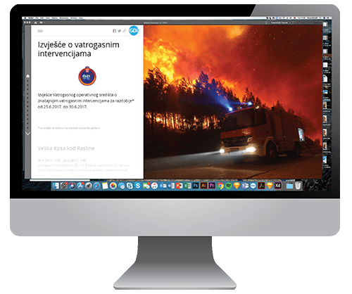
The interactive maps help you tell a thrilling story in a new way by combining authoritative maps with narrative text, images, and multimedia content. They make it easy to harness the power of maps and geography to tell your story.
Check out these local examples:
The Contest rules
The competition OPENS at:
09:00 hrs on Monday 14th January 2019
The competition CLOSES at:
24:00 hrs on May 5th 2019
Selection of winning entry:
Story Maps will be judged based on creativity and relevance to the local area, and how well you can educate someone about your local community
The Story Maps Contest results will be published on 1st June, 2019 at 12:00.
How do I access the ArcGIS Online Public License?
The public account is a FREE account available at www.arcgis.com.
In the map viewer interface, a web map can be created using the map and feature services that are publicly shared. The web map can be saved to the content area of your personal account on www.arcgis.com. Once shared, your Story Map is publicly available to all users (persons or organizations) of ArcGIS Online. Content includes maps, applications, and files contained within your personal content area.
We look forward to seeing your entries!
Time before close of Story Map Contest
NOTES ON PRIZES
*ArcGIS for Personal Use includes:
- ArcGIS Desktop Advanced (ArcGIS Pro and ArcMap).
- The most popular ArcGIS Desktop Extensions.
- ArcGIS Desktop software updates.
- ArcGIS Online Named User Account.
- 100 service credits for data storage, premium data access, and geocoding and analysis.
- A suite of ready-to-use apps for use anywhere, on any device.
- A Living Atlas of the World with maps and data, including access to foundation content from Esri, on thousands of topics.
- Installation support.
- Unlimited access to self-paced e-learning on the Esri Training website.
**Esri Academic Departmental License (medium)
| ESRI Academic Departmental License (Medium) | Number of users |
|---|---|
| ArcGIS Online Level 2 Named Users | 50 |
| ArcGIS Enterprise Level 2 Named Users | 50 |
| ArcGIS Online Organization Account | 1 |
| ArcGIS Online Service Credits | 25,000 |
| Apps | 50 |
| Premium Apps | 50 |
| ArcGIS Desktop | 50 |
| ArcGIS Desktop Extensions | 50 |
| ArcGIS Enterprise Advanced | 1 |
| ArcGIS GIS Server Extensions | 1 |
| Esri CityEngine Advanced | 50 |
| ArcPad | 50 |
*** Creating Story Maps with ArcGIS:
“Thanks to their engaging user experience, story maps have achieved mass appeal as a vehicle to inform the public, engage stakeholders, and inspire an audience. This course is for anyone that wants to communicate with maps. It teaches the concepts, best practices, and decisions that need to be made when creating and sharing a Story Map.”
**** Putting ArcGIS to Use Across Your Organization:
“In this course, you explore ArcGIS apps used for mapping and visualization, data collection and management, spatial analytics, and collaboration and sharing. Discover how the ArcGIS platform helps organizations address common business challenges and apply location-based insights to streamline operations and improve decision making.”
Share with others


